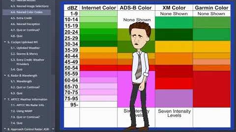
In short: NEXRAD colors are not standardized across weather providers, so Rod Machado teaches pilots to interpret returns by their dBZ values and to check each product’s color scale. He also stresses that uplinked NEXRAD is several minutes old, which makes it a strategic planning tool, never a map for weaving between thunderstorms.
Video: “Radar Imagery Explained Interactive eLearning Course” by Rod Machado, from his YouTube channel.
What you’ll learn
- Why red and green don’t mean the same thing on every radar display
- Why dBZ values, not colors, are the reliable way to judge returns
- Why you should always check a product’s color calibration scale
- How old uplinked NEXRAD imagery can be when you see it
- The 20 nautical mile avoidance guideline for returns of 40 dBZ or more
Colors are not a universal language
This excerpt comes from Rod’s Radar Imagery Explained course. His first warning is simple: displays from different weather providers do not all use the same color coding for the same levels of radar return. Red usually means bad and green usually means better, but exactly how bad or how good varies considerably from one source to the next.
That is why Rod teaches you to identify returns and their associated turbulence probability in terms of dBZ values. He shows a regional radar scale with an entirely different color set, plus a comparison of several popular NEXRAD presentations side by side. If you are not already familiar with a particular product, look at its calibration scale before drawing conclusions.
Old news in a fast-moving storm
Rod also emphasizes that NEXRAD is not real time. By the time it reaches your display, the image can be 5 to 6 minutes old, which is significant given how quickly thunderstorms evolve. Cockpit uplink weather from providers such as XM and WSI is fundamentally different from onboard airborne weather radar, which shows what is happening now.
His conclusion is blunt. Trying to use uplinked NEXRAD to penetrate a line of convective weather is a serious mistake. What you see may be close to reality, but close is not the same. Use the display to judge the likelihood of convective weather along your route, and treat it as one input among many in your en route weather decisions.
Keep your distance
Used in its proper place, uplink NEXRAD is extremely valuable. Rod’s guideline is to stay at least 20 nautical miles away from any boundary of convective activity showing returns of 40 dBZ, level three, or higher. According to the course description, the full program also covers how airline pilots use airborne weather radar, how NEXRAD charts are generated, and other sources of radar information such as approach and departure control and Center imagery.
Go deeper with Rod Machado
Rod’s full course goes deeper into airborne radar, NEXRAD generation and other in-flight radar sources. Learn more in Radar Imagery Explained eLearning Course.
Looking for a flight instructor or flight school near you? Browse instructors and training programs on Skyfarer.
Affiliate disclosure: Skyfarer may earn a commission from qualifying purchases via our links. This funds our content for pilots.